 Open Historia
The World Map
Reading the map: political fills, striped disputes, groups' areas, labels, projections, the 3D globe, terrain and basemaps — and on beta the diplomatic map, war, seasons and weather.
The map is the game's main display and its main control. Everything on it is clickable, and the way it is coloured tells you who holds what.
Political fills
Each country is drawn as one surface in the colour of whoever administers it, with its frontiers stitched between neighbours, rather than as a patchwork of separately filled regions. The fill strengthens as you zoom in — about 46% with the whole world in view, 72% at regional zoom and 84% close in — so relief and seas read from far out and ownership reads clearly up close.
A campaign opens under a loading screen, the logo turning over a dark ground, while the map works out every country's surface. That pause is normal, not a hang; the map is revealed once it is drawn. Switching the 3D globe on or off shows the same screen while the map redraws.
Colours are resolved in a fixed order: the scenario's own palette first, then any colour set on the country, then a match against known aliases, and finally a colour derived from the country's name. That last fallback is why an invented faction always gets a colour even if you never picked one — and why two countries occasionally land on similar shades.
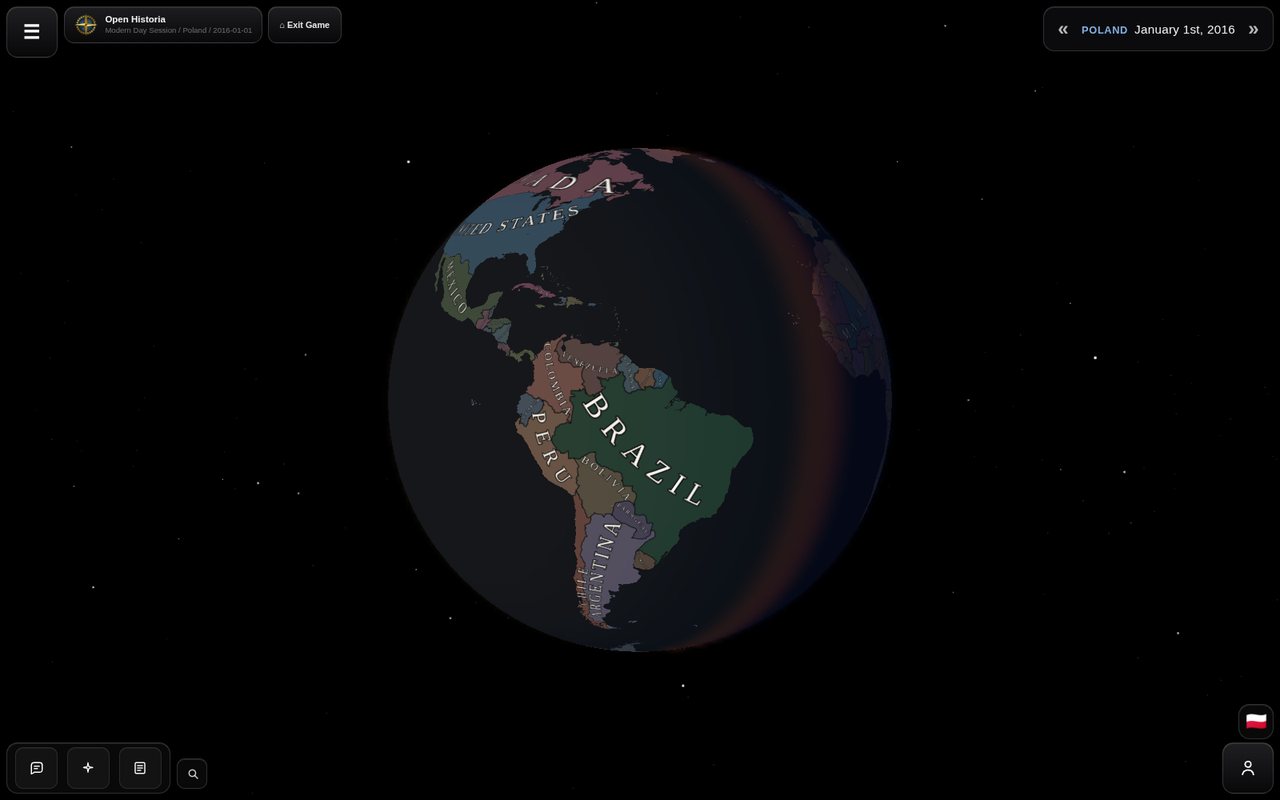 The globe, with the real day/night terminator falling across the Atlantic and the starfield behind it.
Striped regions mean a dispute
A region rendered in stripes is claimed by more than one country. The stripes combine the colour of whoever actually administers it with the colours of the claimants.
This is a real mechanic, not decoration — see territory for the difference between holding ground and being acknowledged as its owner.
Groups' areas
Not everything that holds ground is a country. A group — a cartel, a militia, a movement, an outbreak — can control an area without owning it. Its area is drawn over the countries' colours with a light tint in the group's colour, an outline around the whole area and the group's name; the regions in it stay their countries', and nothing about it is a border. Click a region inside one and its card shows Group control, with the group's name and what it is. The story creates, moves and ends groups as it goes. On beta a scenario or a game can switch groups off, and then no area is drawn.
Map modes
Beta channel only.
On beta the map has two modes, switched at the bottom right under the advisor's button or in Settings → Map → Map mode:
- Political — every country in its own colour, as described above.
- Diplomatic — every country, and the ground taken on a battlefield, in the colour of where it stands with you. A legend beside the switch says what each colour means: You, Puppets, Allies, Friendly / Trade, Hostile, At War and Neutral.
Each time the game opens, the map starts on Political.
War on the map
Beta channel only.
On beta, where a land war is fought on a battlefield, the battlefield is drawn over the map: the ground each side has taken, painted in the colour of whose troops took it; the troops as counters where they stand; and behind them arrows along the way they have come. The front is where the colours meet. Aircraft circle over battlefields that have them, a battle at sea is marked where it was fought with a ring and a cross, a blockading fleet has a dashed ring round the water it closes, and a missile or bombing raid an event tells of is flown across the map when it happens. See the War Room and war at sea.
Labels
Each country gets one label: curved along its territory where it fits, a straight one where it does not, placed so compact countries read horizontally and long ones follow their length. Detached land of consequence — Alaska, Kalimantan, Greenland — carries its owner's name as well. Labels use the name the scenario gives the country, so a renamed country is labelled by its new name. They scale with the map and fade out by zoom 7.5, once the provinces read on their own (on beta they begin to fade at zoom 5 and are gone by 6.2). Cities appear from about zoom 3.4 and get more numerous as you go in.
Scenario authors can set the label font, letter colour and border colour for their world, so a custom map may look quite different from Modern Day.
You can turn country labels off (Hide country labels), or override the label font, in Settings → Map.
Zoom and bounds
The camera runs from zoom 2.25 (the whole world) to 16 (street level, where the basemap supports it). Vertical panning is bounded at roughly 80°S to 85°N — there is no reason to fly off the top of the map.
On beta the camera also turns and tilts, all the way round and up to 60° from looking straight down, on the flat map and the globe alike. The controls are in the interface.
Basemaps
The imagery under the political fills. Settings → Map → Basemap starts on Scenario default — whatever the scenario's author chose, which for Modern Day is Ocean — and offers fourteen others:
| Atlas Relief | Bathymetry and shaded land relief, graded as a political canvas |
| Atlas Relief - Dark | The same, darker |
| Satellite | Photographic imagery |
| Streets | Roads and place names |
| Topographic | Contours and relief |
| Terrain | Physical terrain base |
| Shaded Relief | Hillshading only |
| Physical | Natural-earth style |
| National Geographic | Atlas styling |
| National Geographic - Dark | Atlas styling, darkened, without political or place labels |
| Ocean | Bathymetry and a muted land base |
| Ocean - Dark | The same, darker |
| Light Gray Canvas | Minimal, light |
| Dark Gray Canvas | Minimal, dark |
Your choice is stored per browser and overrides the scenario's; it applies immediately. Setting it back to Scenario default hands control back to the scenario. A scenario drawn on a map of its own — a picture, a drawn map, the plain sea of a flat sheet — keeps it: there the list is greyed out and says so.
Not every basemap has imagery at every zoom — Physical stops at zoom 8, Terrain and Shaded Relief at 13. Past that the game upscales the last available tiles rather than showing nothing.
On beta the list is the scenario's maps. In a game, Basemap offers its scenario's starting map, any maps of its own, and the built-in ones it allows — every one on a real-world scenario, none on an invented one — and your pick is kept for that game only. The main menu's Settings has Use my default basemap, a built-in map every game starts on wherever its scenario offers it. Beta also has a fifteenth built-in map, Midnight Terrain, a very dark physical canvas with no names on it.
The 3D globe
Settings → Map → 3D Globe swaps the flat projection for a sphere.
It is not just a projection change. The globe carries a real day/night terminator computed from the actual subsolar point, a starfield, and a sun sprite — the lighting corresponds to the real world clock, refreshed every minute. Left alone, the globe rotates slowly, a full turn every ten minutes.
Both the idle rotation and the general motion can be switched off — Disable idle globe rotation, or Reduce motion as an umbrella setting.
A scenario whose map is a flat sheet rather than a world can switch the globe off for its map; the switch then says The 3D globe is disabled for this scenario's map.
3D terrain
Settings → Map → 3D Terrain, marked experimental and honestly so. It raises real elevation with a 7.5× exaggeration so that mountain ranges actually read at world scale, plus light hillshading. A scenario with a custom background has no elevation data to raise, so it stays off there.
Custom backgrounds
A scenario can replace Earth entirely, either with an image pinned to a geographic extent or with its own vector artwork. This is how fantasy maps work: the political layer sits on top of a world that has nothing to do with this planet.
A scenario's map can also keep the projection it was drawn in — Mercator, Equirectangular, Miller, Gall-Peters, Robinson, Natural Earth, Equal Earth, Mollweide, Sinusoidal, or Freeform, a flat sheet of any shape — so a flat map or an invented world arrives undistorted. Its author can also stop the map repeating sideways as you pan past its edge. Projections are set in the map editor.
On beta a scenario can have detailed maps. These are large terrain maps that stay sharp however far you zoom in, drawn over the scenario's own map in the desktop app. Each downloads once, is checked, and is shared by every scenario that uses it; on the website, on Android, or without the download, you see the drawn map underneath. In a game, Settings → Map lists the scenario's maps by name, and under Detailed maps a line says which are missing or out of date, with Download… beside it.
Seasons and weather
Beta channel only.
On beta the world has climates. The whole map is faintly tinted by the season each place is in on the game's date — winter a cold blue-white, spring green, summer a warm yellow, autumn amber — following climate zones drawn across the world: the real world's on the built-in maps, or a scenario's own.
Each zone has one weather at a time — clear, rain, storm, mud, snow, blizzard, frost, heat or fog — drawn over the land as a patch in the zone's own shape, thinning at its edges into the zones beside it. Clear skies are the commonest weather nearly everywhere. Nothing is written on the map: ask your advisor for the season and the weather. Lakes and seas frozen hard enough for troops to cross are drawn as cracked ice, whatever the switches below say, since they change where armies can go.
In Settings → Map, Seasons and weather (on by default) turns the tint and the weather on or off, and Weather effects under it the weather alone. A scenario can also fight its wars without weather, and then none is drawn. What the weather does to armies is on the War Room page.
Clicking things
| Click | You get |
|---|---|
| A region | A card naming the country and the region, with 💬 to open a chat, ⧉ to copy the name and ⓘ to open the country's panel. An occupied or contested region also shows who is sovereign, who controls it and who claims it, and a region in a group's area names the group. |
| A country's panel | Flag, details, alternative names, related events filtered by importance, and an AI report on request. |
| A unit | An intelligence card — what the formation is, whose, how strong, what it appears to be doing. Not a command panel. |
| A city or structure | Name, population, whether it is a capital, and what kind of thing it is. |
Performance
If the map is slow:
- Turn off 3D terrain. It is the most expensive thing on the list by a wide margin.
- Turn off the globe. The flat map is cheaper.
- Reduce motion, which quiets several animations at once.
- Zoom out. Fewer tiles, fewer labels.
The map caches a bounded number of tiles deliberately, to avoid running a browser tab out of memory on a long campaign.
On beta, Settings → Map has Performance mode. Auto picks Low memory in the Android app, on a touch screen with no mouse, and on a device with 4 GB of memory or less: the map then loads in smaller steps with fewer workers. Full is faster on a strong tablet, and Low memory can steady a weak computer. A change applies after the game is reloaded.
Next
- Territory — what the stripes actually mean.
- Cities and structures — the things drawn on top.
- Settings — every map option in one place.
Open Historia is under active development on two channels, and this
wiki is written by hand — a page can fall behind a release. Last checked against the game on 2026-10-25 · main 6e6239c4 · beta d7e8fa85. If something
here does not match what you see in the game, trust the game and
say so on Discord.